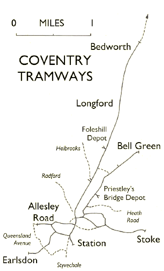
Coventry's Tramways at their Peak
The last extension to the tram system in Coventry took place in September
1930. The first route was withdrawn in March 1932. The solid lines on the map
show the system at it's peak between these two dates.
|
Plans were considered to add routes or extensions of routes serving
- Allesley Road to Queensland Avenue,
- Bedworth to Nuneaton,
- Binley Road to Uxbridge Avenue,
- Corporation Street,
- Harnall Lane East, Swan Lane and Heath Road,
- High Street, Earl Street, Jordan Well and Gosford Street to Lower Ford
Street,
- Lockhurst Lane and Foleshill Station to Holbrooks,
- Queens Road and The Butts,
- Radford Road to the City boundary,
- Station Street East linking Foleshill Road with Stoney Stanton Road,
- Warwick Road, Spencer Road, Belvedere Road, Earlsdon Avenue and
Queensland Avenue,
- Warwick Road to the Styvechale Boundary.
These are shown on the map as broken lines, with the destination points in
italics.
|
|
Contents © Ken Crawley 2000 & 2001 |
|